Extract from The Guardian
While the east coast has flooded, other areas see below average rainfall as climate crisis means ‘the wet getting wetter and the dry getting drier’.
- Sign up for the Rural Network email newsletter
- Join the Rural Network group on Facebook to be part of the community
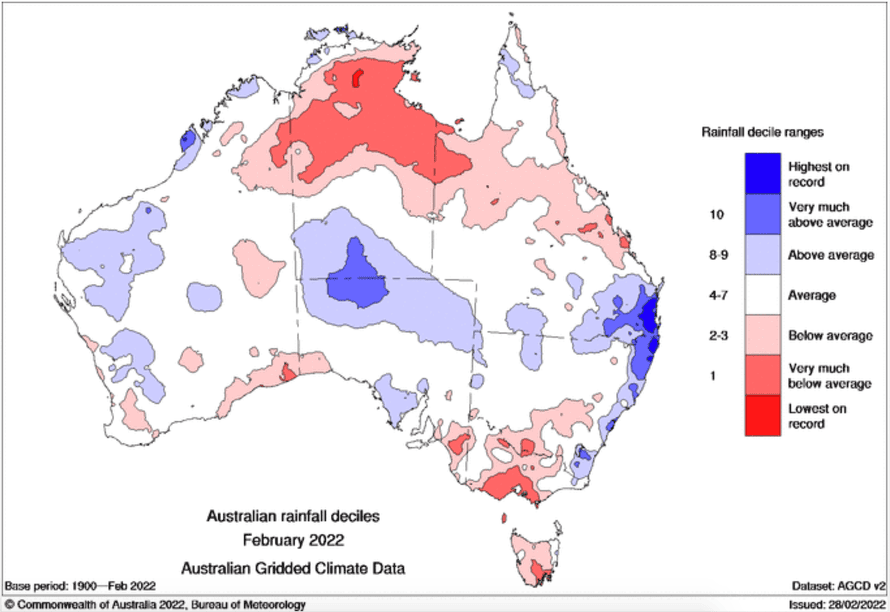
Northern Australia has experienced well below average rainfall, as well as Tasmania, south-east SA, most of Victoria and parts of WA.
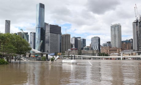
The Bureau of Meteorology data shows that in the past month, as heavy rain has hit south-east Queensland and coastal New South Wales, northern Australia has experienced well below average rain.
The latest bureau report also shows that February rainfall was below average for Tasmania, south-east South Australia, most of Victoria and parts of the southern coast of Western Australia.
David Karoly, a professor in geography, earth and atmospheric sciences at the University of Melbourne, says that it is typical of a La Niña event to see increased rainfall in northern and eastern Australia, as well as drier conditions in the south-west of Australia as the “other part of La Niña”.
However, Karoly says because climate change is “superimposed” upon these patterns, it exaggerates the more typical La Niña conditions, meaning “the wet getting wetter and the dry getting drier”.
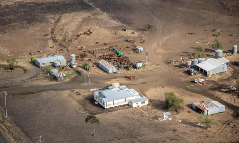
Carly Veitch, a wheat and sheep farmer at Quairading in Western Australia, said while bad bushfires in the past had all happened in the hills and tree country, the most recent fires which affected her neighbours 50km away were in very flat open farming country – “the sort of area you’d never think you were in danger or wouldn’t have time to get out”.
She said the extreme heatwave and fires in WA have started more discussion about greater preparedness for climate change at a local industry level. “It’s starting to feel like we’re living it now rather than something that could happen in the future.”
However, Karoly said the weather in the northern part of the country has been more unusual. While the wet season started off fairly wet for northern Australia, the dry February and early March is not typical.
Warren Entsch, the federal member for Leichhardt, told Guardian Australia “half-jokingly, those in the south have taken all our rain”.
Bruce Currie, a cattle farmer in the desert uplands bioregion in central west Queensland, said the benefit of the big rain event in November has been negated by the subsequent heat.
“It doesn’t matter how much rain you get, if you get severe heat conditions afterwards the transpiration and evaporation from the soil burns your country off.”
When the drought hit back in 2017, Currie took his stock off the property. He’s been trying to rebuild his cattle numbers, but says if the area doesn’t get a normal season and the heat keeps burning off the pastures, he’ll be back to de-stocking in three months.
The move to de-stock, he says, comes as “we try and protect our ground cover and our land and our environment”.
“The land is everything. If you don’t look after your land, your land can’t look after your stock, can’t look after you, and the impacts from having degraded landscapes impacts downstream people,” said Currie.
“The water runs off quicker, it causes more severe flood events, it silts up infrastructure like dams and weirs, it muddies the water, if you’re in the reef catchment it goes out on to the reef and impacts the fishing and tourism industries.”
Currie says he is starting to worry how he and his neighbours can manage the fire risk posed by the premature drying off of the grasslands.
Steve Turton, a professor of environmental geography at Central Queensland University, says the oppressive heatwaves in north-east Queensland and WA are due to stalled weather patterns caused by “blocking” high-pressure systems.
Turton believes you still have to “wait until the fat lady sings”, as more rain could arrive in the wet season which lasts until April. “I think La Niña has one more burst up her sleeve.”
Entsch believes this too, as he’s had more heifers than bulls born on his cattle farm this year, which acts as his indicator of a good season.
Karoly said in a more typical La Niña event you would get rain not just in the coastal area but also substantially inland, but the lack of rain inland is related to the dryness in the northern wet season regions.
Angus Whyte, a sheep farmer in south-west NSW, 80km away from both the SA and Victorian borders, says while the drought isn’t as severe as 2017-19, he’s still “teetering” – unable to get back to above average seasons and fully restore his soil moisture.
“We’re still in dry time.”
He de-stocked to 20% of his livestock in 2017, and while he’s now back up to 60%, it’s still not back to 2016 levels.
“You wouldn’t say we haven’t got rid of the drought – that it’s turned around.”
Whyte says while his heart goes out to all those affected by the flooding, he can’t help but feel there are often generalisations made about conditions in coastal areas affecting the whole of the state when there is so much variability even in the one state.
No comments:
Post a Comment